
Co-design Session #2 Synthesis Report
The second of three co-design sessions focused on the topic of Dynamic Streets. At this session participants were tasked with discussing their current experiences navigating streets, brainstorming solutions, and prototyping their ideas. For the discussions, groups were assigned one of three topics related to dynamic streetscapes: managing conflicting needs in shared spaces, wayfinding and orientation in dynamic spaces, and shared spaces that are perceivable, operable, and understandable for all. For more information about this session please visit the Co-design Session #2: Dynamic Streets post.
Overarching Themes
Co-Existing: Managing conflicting needs in shared spaces
The participants reported conflicts between pedestrians, drivers and cyclists who all share intersections and often find themselves in conflict with each other. Participants also discussed inter-pedestrian conflict for example when the needs of slow walkers and fast walkers conflict when sharing the sidewalk. Further, participants discussed the multi-uses of sidewalks that often conflict with each other, for example street furniture (trees, benches, garbage bins, bike racks, signs, bus shelters), street sports, street festivals and construction interrupts the flow of foot traffic and acts as a barrier for pedestrians (e.g noise, debris etc).
The groups discussed that these conflicts occur because sidewalks are meant to serve multiple purposes, and there is a lack of coordination to accommodate all uses. The participants also reported that the city infrastructure is built to be permanent which is not compatible with the changing needs of the users. For example, traffic lights do not adequately manage the flow of traffic and they lack multimodal signals for all users.
The groups suggested different ways to enable multiple uses of streets that will be accessible for all. These included enforcing strict rules to manage the uses of sidewalks, for example allocating spaces for different uses (e.g. garbage bins, ramps, pedestrians, etc.) to reduce conflict. Also, to improve the usability of sidewalks for pedestrians with different needs, the groups suggested having a mandatory training program for all pedestrians (e.g. walking license), create separate lanes for people with different walking speeds, and pedestrian overpass and underpass. Other means to regulate shared street use included opening and closing streets to manage drop offs, coordinating and planning construction, more adequate management of traffic lights and public shaming to discourage inappropriate parking (e.g. honk if person double parks).
Lost & Found - Wayfinding and orientation in dynamic spaces
During groups discussions, participants shared different strategies they use to navigate the streets: travelling by foot or via public transit (subway, buses, streetcars), relying on Google Maps/Earth, street signage, curbs cuts, curbs, landmarks, pictures, sounds and smells, tactile strips, street beacons with BlindSquare app, asking directions from other pedestrians and familiar neighbourhoods as markers to help them find their way around the city.
Participants reported instances of getting lost in the city often due to poor signage (inappropriate or inconsistent placement and language, which included street names, directional signage, and subway station signage). Groups also discussed the unnotified construction and associated changes in landmarks that cause confusion in navigating the streets and contribute to getting lost in the city. Other factors included broken elevators in public places (e.g. subway stations) and the lack of proper directions and signage to help people using mobility devices reroute and reach their destination. Similarly, people felt overwhelmed with the overcrowded city streets, incorrect GPS routes and directions, and the lack of U-turn and left turn options in the city that made navigating the city while driving very difficult.
After discussing their challenges, participants brainstormed strategies to navigate a space that is constantly changing. Some of the strategies included using visual, haptic, and auditory indicators, live maps, observation, dynamic signage and consistent furniture placements (e.g. benches at north side of street and food on south side) to help them navigate the streets successfully. Groups also discussed receiving information directly from the street through sensors and notifications that would connect to their personal technological devices. Other groups also discussed using landmarks that can be moved in times of construction and road blocks, and replanted in other locations to help with navigation. These landmarks will have consistent and predictable features (e.g. color, texture, shape, size, sound) that can be learned to easily locate these markers throughout the city. Other ideas included incorporating fixed, unchanging “safe/rest spaces” or fixed light poles for people to use to orient themselves in the city.
A city working for everyone: Shared spaces that are perceivable, operable and understandable for all
For this theme, participants shared that they enjoy uncrowded streets with wide sidewalks, green spaces, and multi crossings. They suggested having easy and quick access to benches and rest areas for people and animals, accessible public washrooms, and garbage cans that are functioning properly makes the streets more accessible for them. Some participants pointed out that a historic or art element, such as statues, public art projects, graffiti, etc enhances their street experience. Groups also talked about how changes in texture/color on the streets (e.g. different texture at the curb cuts) and receiving audio notifications (e.g. beeps at the traffic lights) can support their safe navigation of the streets.
On the other hand, groups discussed that areas that are commerce based, car dominated, crowded, cluttered with street furniture/ trees, or obstructed by construction don’t work for people particularly if they have accessibility needs. Another aspect that led to confusion and feeling lost for several participants was unpredictability and sudden changes in the environment. One example is construction, and how it forces different street users to take alternative routes. The other example discussed related to the inconsistent signage, and wayfinding indicators across different parts of the city (e.g. using different materials for sidewalks in different neighbourhoods). Participants also expressed that, the unpredictability issue will be more problematic in a dynamic street setting particularly for people who can’t easily adapt and are afraid of change. Lack of communication about the nature of different spaces, whether they are public or private, policed or under surveillance, have specific schedules or any other restrictions made some participants hesitant to use particular spaces across the city. Groups also found street signs, and bus stops difficult to find particularly when bus drivers change routes. The arrangement of the streets, having streetcars in the middle requiring passengers to cross car lanes and bike lanes to get to the sidewalk was another aspect of the streets that made crossing of the street a more challenging task particularly for participants with accessibility needs.
Participants suggested using multi-sensory indicators, such as air bursts, vibrations, tactile markers, contrast strips, and audio feedback to indicate different street zones and inform people when they are transitioning from one zone to another. They also discussed utilizing technology across the city to make the streets more accessible. Some of their ideas include providing more accurate GPS locations, embedding beacons technology in store fronts/ intersections/ different parts of streets, providing adaptive traffic lights and interactive information kiosks across the city, and making Wi-Fi widely available across the city. Several participants also indicated that providing means to easily notify others of construction, or any other obstructions on the street and informing them of alternative routes could significantly help their navigation across the city.
Prototypes
During the afternoon, participants continued to build on their ideas and developed a prototype. Here is a brief description of each group’s prototype:
Kiosk
Description:
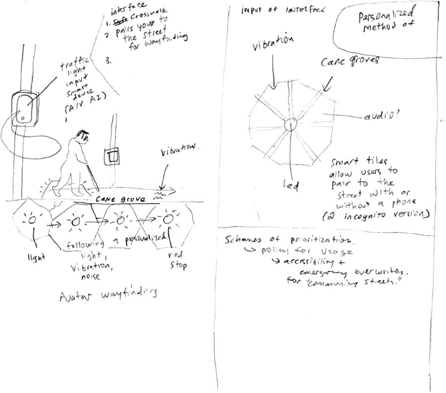
This team proposed creating a multisensory interface located near intersections and various other locations to help pedestrians safely navigate the space. Through use of AI (Artificial Intelligence), this interface is able to detect the pedestrian’s communication need and provide contextual information about their surroundings in a language and with a modality that they prefer.
During the peer critique, other groups suggested that this solution may not be accessible for people who are not accustomed to technology as well as other users of the space, such as drivers, bikers and people using mobility devices. They were also concerned about the pedestrian’s privacy and security as this interface would use face recognition and personal stats to identify their needs and adapt its setting. Other comments related to cost, sustainability and maintenance of such solution throughout the city.
Tactile Strip on Sidewalks
Description:
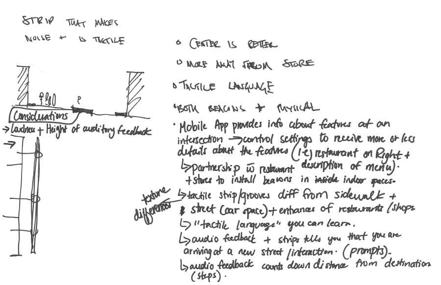
This group proposed a tactile strip to guide pedestrians when crossing the street. This guided walk helps pedestrians with finding addresses, and orienting themselves in space. The tactile strip is integrated with a mobile app that provides audio feedback and more detailed information about street names, features at an intersection, and stores. A combination of the strip and the audio feedback informs pedestrians as they arrive at a new street/intersection. Audio feedback can also count down distance from the destination (steps).
The app enables users to control how much information they would like to receive about their surroundings. This team also suggested a partnership with restaurants and stores to install beacons to help pedestrians navigate indoor spaces.
Some of the feedback this group received related to implementation challenges and integrating this strip in all streets. They also mentioned the tactile strip may cause difficulty for people with balance issues, and would not be accessible for deaf and deaf-blind users. As a response to this feedback, the group proposed adding vibration to the audio feedback. They also proposed using removable tactile strips, so they can be easily added to most streets without further need for construction.
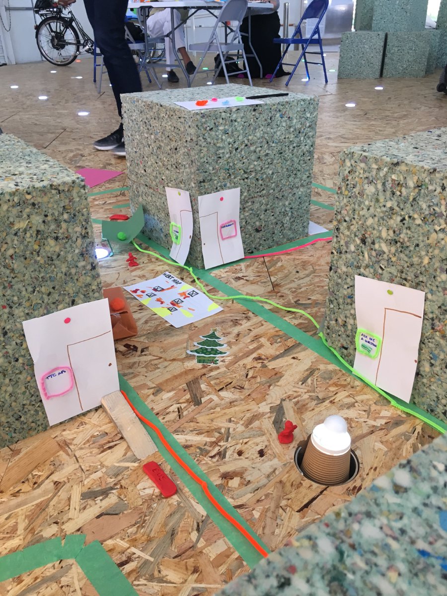
Hexagons with “Braille Trail”
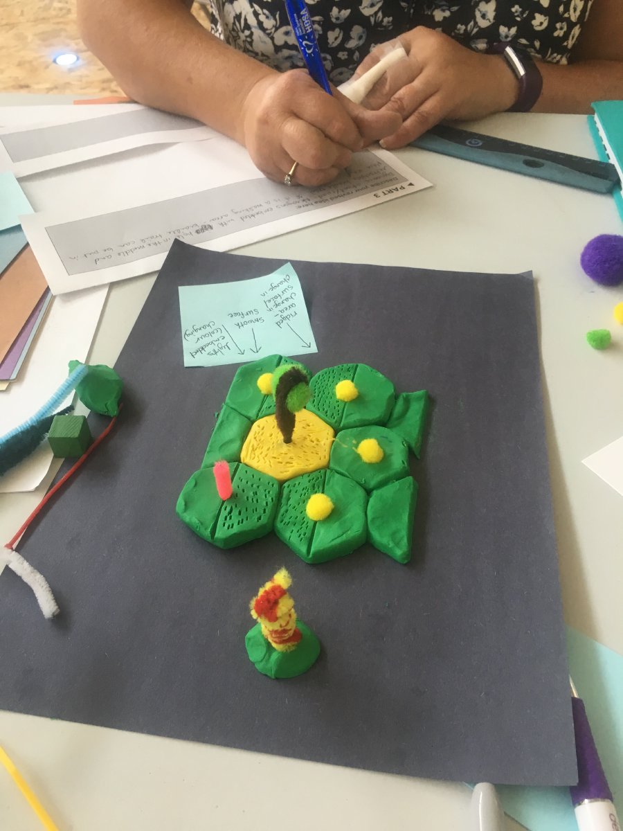
Description: This group’s idea was integrated with the Sidewalk dynamic street hexagon tiles. They proposed that each hexagon could have a hole in the middle and retractable braille trail. The hole in the middle can be filled with trees, lights, poles, or moveable landmarks. IoT (Internet of Things) or other related technology can be integrated in the tiles in the walking areas. The moveable landmarks would have an embedded beacon technology that can be triggered via a button to provide location details for pedestrians. The beacons can be reprogrammed to provide different kinds of information. One of the main feedback this group received was related to the removable landmarks and could be confusing or disorienting for some people.
Optimized intersection
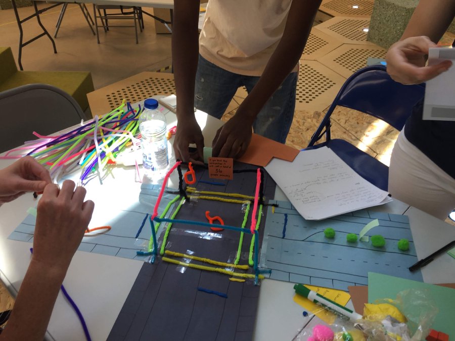
Description: This group proposed an intersection that is optimized for pedestrians and cyclists and designed to reduce vehicle volume, congestion, and blockage. To achieve this goal, the group suggested dynamic pricing for cars to drive through the intersection. They also integrated signage to indicate to vehicles cost of blocking intersections in order to encourage good behavior. To promote safety, they staggered bicycle (yellow stop line) and car stops (blue stop line), and added tactile crosswalk boundaries (yellow and green lines). This intersection would be equipped with adaptive signals that change based on real time demand and contextual data (e.g. extend a walking sign so pedestrians can catch an incoming train) and audible signals will be integrated for the visually impaired pedestrians.
One of the main feedback this group received was related to high volume of information being communicated at this intersection via signage and different types of indicators. They found this to be confusing and somewhat overwhelming particularly for people with developmental delays, processing issues, reading barriers, and language barriers. They also found the pricing strategies to be a financial barriers for groups that have no other option than using their cars (e.g. people travelling from out of town, or using mobility devices).
In response to the feedback they received, and to further ensure understandability of signage, the group consolidated their signage into one dynamic sign that only would only display the most important messages at a time to prevent information overload. The group also incorporated a dynamic pricing system for each vehicle based on transportation alternatives and income and travel origin.
Pedestrian/Community Focused Neighbourhood
Description: This group focused on designing streets that allow for easy navigation by pedestrians. They tried to encourage wayfinding as an activity, experience and social connection. They focused on city blocks and tried to create micro communities. They incorporated a coded navigation system with texture, color, vibration and smell within each of these city blocks. They also capitalized on landmarks in each block to amplify navigation. They also suggested integrating technology in buildings that are facing pedestrians in order to facilitate wayfinding.
One of the main feedbacks this group received was related to all the different ways and cues to be able to navigate this area. Many of these navigation methods / cues require education, otherwise they would be ignored. A combination of all these different navigation methods can also lead to sensory overload, confusion and feeling lost in this area, particularly for people who are in a rush.
Themes that emerged from the Prototypes
The prototyping activity enabled us to draw out specific qualities that the participants thought were important and should be included in the design of inclusive cities.
The group prototypes suggested that participants valued incorporating artificial intelligence to develop systems that allowed pedestrians to directly connect to the street and receive feedback and directions in multiple modalities from the street itself. Groups also emphasized the importance of developing multimodal systems that allow pedestrians with different needs and capabilities to safely cross intersections. The design ideas incorporated mobile apps that would be connected directly to traffic lights, provide multi-sensory and multilingual prompts to indicate when to cross, and sensors that detect pedestrians and control traffic lights to ensure safe crossing at the intersection. Further, designing a neighbourhood that focused on the needs of pedestrians was also an important topic of discussion among groups. Two groups developed prototypes that ensure ease of navigation for pedestrians through better signage systems (multi-sensory and multilingual), dynamic landmarks, and through the incorporation of IoT technology to provide real-time data on changes in the environment and guidance on how to safely and effectively navigate these changes.
The IDRC team went through all the notes and the artifacts from this session and extracted as many ideas as possible for the hackathon session. The IDRC team and Sidewalk team went through these ideas once again and picked about 3-4 ideas to be built during the hackathon.
Raw Data
- Scanned images of the group worksheets and peer feedback from the entire session (PDF)
- Tables generated based on the collected information in co-design session#2 (Word document)